With Boomer on the mend, I wanted, no needed, to hike something new that wasn’t too far or too crowded. I read recent trip reports on Perry Creek and it sounded like a good hike with some adventure. Some folks made the ridge and others turned back — looked like a challenge.
So we started hiking at about 9:45AM. The trail shares the same parking lot as Mt. Dickerman, a good workout that’s better later in the season. There was only one other guy on the trail ahead of me.
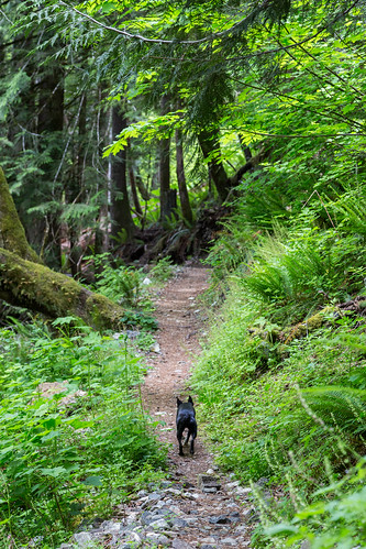
Boomer was definitely himself and did his usual bolt ahead as soon as we hit the trail. The first mile of the trail is quite serene as it makes its way from the lot to the old and now inaccessible trailhead, meandering through old growth trees. Once you get away from the road, the silence is very welcoming.
After a short walk on the road to the old trailhead, you hit the main trail which leads to Perry Creek and Mt. Forgotten Meadows on the top of the ridge; today’s goal.
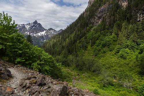
The trail climbs steadily as it alternates between old growth groves and open talus traverses. Here’s a shot looking back down the valley toward Hall Peak. Big Four Mountain is out of view to the left.
At the three mile mark I was happy to come to Perry Creek Falls to take a break and shoot.
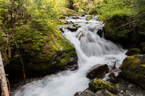
I didn’t take the time to set up my tripod, but was able to get a few decent hand-held shots, thanks to the image stabilization in my lens.
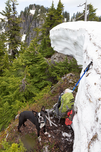
After another 100 yards or so, I changed out of my boots and put on my new Keen sandals, picked up Boomer and waded across the chilly creek. Glad it was only calf-deep.
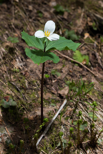
With feet dry and boots back on, we headed up the steeper switchbacks to the ridge. Lots of flowers along the way, including this lone trillium.
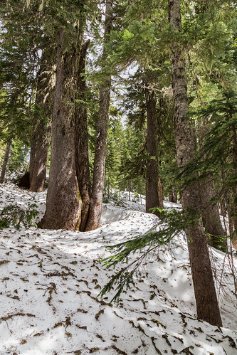
We hit the snow at about 4,500 ft, and it was all snow from that point up. There was a hint of a trail, as the guy in front of me went about half way up the snow before getting frustrated with the lack of trail and headed back down. I went past his tracks with the help of my GPS and knowing it was just a straight shot, continuing the switchback.
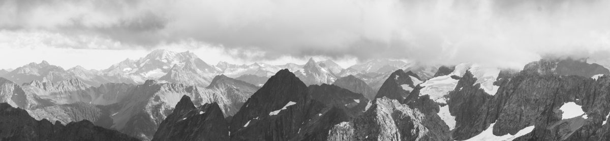
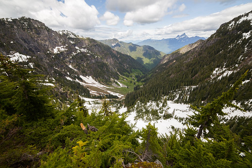
After reaching and exploring the ridge, I shot this 360 panoramic (best viewed on a PC).
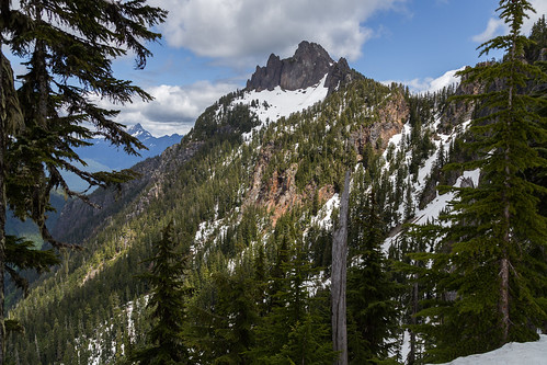
Here’s a shot of Mt. Forgotten, with White Chuck Peak in the distance.
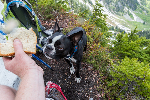
We then looked for a snow-free spot to sit and eat our lunch. The only spot I could find was a little ledge at the edge of the snowbank on the north side of the ridge. It was at most 3 ft wide, with a drop of a few hundred feet. I carefully dropped down there and plopped Boomer beside me, enthralled with the sandwich I shared.
And I soaked in the huge view from our lunch spot.
We were the first up there, and on the way back down, passed a half dozen more who had already crossed the creek and were heading up. We chatted, exchanging tips and directions.
I was back to the car about six hours after I started, covering 10 miles or so.
View Perry Creek 6/7 9:45 AM in a larger map
Brief trip report is also up on WTA’s site.

Wow that was strange. I just wrote an really long comment but after I clicked submit my comment didn't show up. Grrrr… well I'm not writing all that over again. Anyhow, just wanted to say excellent blog! capital one card login in
LikeLike
Hi, just wanted to mention, I enjoyed this post. It was funny. Keep on posting! paypal login my account
LikeLike
People need to take into account that if rates rise they are able to expect to use a higher payment per month even when they refinance into another IO loan. canada mortgage calculator When it comes for the payment structure, expect commercial loans to vary through the traditional amortizing schedule. canada mortgage calculator
LikeLike
Great Article blockchain projects for students IEEE Projects for Engineering Students JavaScript Training in Chennai Networking Projects JavaScript Training in Chennai
LikeLike
no deposit bonus forex 2021 – takipçi satın al – takipçi satın al – takipçi satın al – takipcialdim.com/tiktok-takipci-satin-al/ – instagram beğeni satın al – instagram beğeni satın al – google haritalara yer ekleme – btcturk – tiktok izlenme satın al – sms onay – youtube izlenme satın al – google haritalara yer ekleme – no deposit bonus forex 2021 – tiktok jeton hilesi – tiktok beğeni satın al – binance – takipçi satın al – uc satın al – finanspedia.com – sms onay – sms onay – tiktok takipçi satın al – tiktok beğeni satın al – twitter takipçi satın al – trend topic satın al – youtube abone satın al – instagram beğeni satın al – tiktok beğeni satın al – twitter takipçi satın al – trend topic satın al – youtube abone satın al – instagram beğeni satın al – tiktok takipçi satın al – tiktok beğeni satın al – twitter takipçi satın al – trend topic satın al – youtube abone satın al – instagram beğeni satın al – perde modelleri – instagram takipçi satın al – instagram takipçi satın al – cami avizesi – marsbahis
LikeLike
aşk kitapları tiktok takipçi satın al instagram beğeni satın al youtube abone satın al twitter takipçi satın al tiktok beğeni satın al tiktok izlenme satın al twitter takipçi satın al tiktok takipçi satın al youtube abone satın al tiktok beğeni satın al instagram beğeni satın al trend topic satın al trend topic satın al youtube abone satın al takipçi satın al beğeni satın al tiktok izlenme satın al sms onay youtube izlenme satın al tiktok beğeni satın al sms onay sms onay perde modelleri instagram takipçi satın al takipçi satın al tiktok jeton hilesi instagram takipçi satın al pubg uc satın al sultanbet marsbahis betboo betboo betboo
LikeLike
seo fiyatlarısaç ekimidedektörinstagram takipçi satın alankara evden eve nakliyatfantezi iç giyimsosyal medya yönetimimobil ödeme bozdurmakripto para nasıl alınır
LikeLike
instagram beğeni satın alyurtdışı kargoseo fiyatlarısaç ekimidedektörfantazi iç giyimsosyal medya yönetimifarmasi üyelikmobil ödeme bozdurma
LikeLike
bitcoin nasıl alınırtiktok jeton hilesiyoutube abone satın algate io güvenilir mireferans kimliği nedirtiktok takipçi satın albitcoin nasıl alınırmobil ödeme bozdurmamobil ödeme bozdurma
LikeLike